
What if decision-making included experiencing the future firsthand? Community leaders can now forecast hazards like hurricanes, model future scenarios, and test strategies to ensure a healthy, resilient and economically vibrant future for Jacksonville’s residents using the JaxTwin, a digital replica of the city. This novel tool, developed by a trans-disciplinary team of UF researchers and in collaboration with corporate technology partners, was showcased at the Optimizing Solutions for Resilient Coasts summit on December 13 at the Austin Cary Forest Campus by CCS affiliates Changjie Chen, Ph.D., assistant scientist at the UF Florida Institute for Built Environment Resilience (FIBER), and Karla Sandaña Ochoa, Ph.D., assistant professor at the University of Florida (UF) School of Architecture.
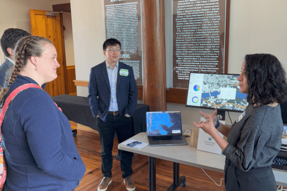
“Digital twins are a unifying technology that combines building information modeling, geographic information systems and artificial intelligence,” said Chen. “By connecting data, tools and processes, they provide a rapid and intuitive way to model and visualize the impacts of decisions.”
The Jacksonville digital twin was developed at two different scales. The first scale represents the entire city of Jacksonville, including 32,000 buildings with integrated data like the year of construction, while another looks at a single city park, Ribault Scenic Drive Park.
At the city level, decision-makers can explore scenarios like flood projections to see which areas will be affected and the potential damage. They can also filter data by factors such as industrial versus residential buildings or the vulnerability of older structures. This “virtual sandbox” lets them test adaptation strategies, like infrastructure upgrades, to make informed and proactive decisions.
On a smaller scale, users can use augmented reality (AR) goggles to design living shorelines at Ribault Scenic Drive Park. The technology allows users to virtually place oysters, vegetation and rocks to test how they strengthen shorelines and reduce flooding. The platform also incorporates data on nitrogen and carbon storage in the digital oysters and plants, which lets users experiment with different designs and compare costs and environmental impacts in real time.
Tom Waters, the director of corporate engagement at the UF Herbert Wertheim College of Engineering, views one of JaxTwin’s greatest benefits as its ability to provide leaders with a safe environment to practice decision-making in complex, high-stakes situations. This preparation helps them prepare for real-world crises more effectively, ultimately saving time, money and lives.
“A crisis management simulation is normally very sterile, trying to boil decision-making down to simple black or white options,” said Waters. “The JaxTwin simulation lets a decision maker ‘see’ that such situations are actually gray and allows leaders to feel the emotional response they would have during such a crisis, so they know how to handle it. It’s something military commanders do on a regular basis, but very few civilian leaders have the resources for it. It’s a very powerful tool.”
Project information:
JaxTwin is a pilot project that was part of the Florida Digital Initiative, a campus-wide, transdisciplinary project launched in 2024 that draws on the diverse expertise of researchers from the UF Herbert Wertheim College of Engineering (including the Center for Coastal Solutions); UF College of Design, Construction and Planning; UF College of Journalism and Communications; UF College of Medicine; UF Health; UF Institute of Food and Agricultural Sciences (IFAS); and UF Information Technology (UFIT) Research Computing. Industry partners include NVIDIA, Mark III Systems, and Deloitte.
—
By Megan Sam