If population growth and land use in Florida continues at its current rate, more than a third of the state’s land could be developed by 2070, potentially doubling the demand for fresh water. A new data analytics tool developed through a partnership by researchers at the UF Center for Coastal Solutions (CCS) and the Center for Landscape Conservation Planning (CLCP) can save Florida counties time and money by helping them make strategic decisions about land conservation projects that deliver the greatest environmental benefits including improved water quality.
“We are running out of habitat for our natural resources and the plants and animals that depend on those, as well as the green space that we as humans enjoy and the benefits those spaces provide to humans,” said CCS Researcher Tricia Kyzar, Ph.D. “We need data driven solutions that can speed up decision-making.”

Growing populations place a strain on freshwater supply resources and can generate water quality problems. Increased development often leads to more impervious, or nonporous, surfaces like concrete or rooftops which accumulate pollutants that runoff waters deliver to lakes and rivers. Reduced habitat in these developed areas may also lead to increased “human-wild animal” interactions with potentially deadly consequences.
The Land Conservation Optimizer Tool integrates a community’s conservation goals and identifies those key lands that, if conserved, would best achieve those priorities, as well as incorporate existing conservation models. The tool generates a ranked list of parcels, potential funding matches for possible conservation project proposals and a summary report for a targeted and data-driven project to conserve land and improve water quality.

“What gets me really excited about this tool is that it is bringing water quality and water storage to the conservation question directly, as well as highlighting how conservation can contribute to improving water quality and supporting water storage,” said Kyzar.
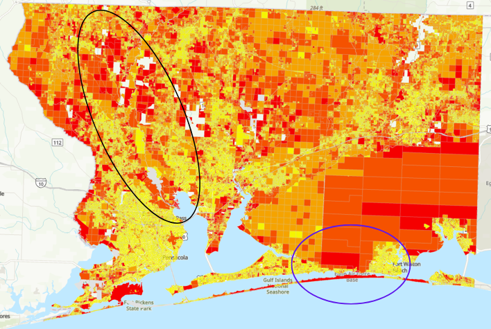
UF researchers have used the tool to help decision makers in Escambia, Santa Rosa and Okaloosa Counties to identify lands that could be conserved to improve the area’s water quality. The Land Conservation Optimizer Tool integrated existing conservation models, data of suitable habitat for threatened and endangered species and environmental data, such as water quality improvement and water storage opportunities. The tool showed lands surrounding the Escambia River corridor and Eglin Air Force Base that were most suitable for conservation because of their potential to improve downstream water quality, store water during a hurricane or big rain event, support agriculture, and protect forest lands and wetlands.
This data analytics tool supports region-wide, coordinated planning of land conservation goals and water quality improvements. As it can shorten the time it takes to identify conservation opportunities by as much as a couple of months, it is one of many CCS products that accelerates the process by which conservation projects can be identified and action taken to achieve the highest environmental benefits for people and places.
“The Land Conservation Optimizer provides a new tool for local and state decision-makers working to identify the highest priorities and best opportunities for land protection, particularly in areas that provide a dual conservation and water resource value,” said Michael Volk, associate director of UF CLCP. “With extensive working, silvicultural and natural lands still existing within northwest Florida, it’s never been more critical to make strategic decisions about land protection — and to identify the best candidates for state, federal and local land protection funds to protect our working and natural lands and water.”