The United States has experienced 23 extreme weather events so far this year, including hurricanes, that each carry losses exceeding $1 billion, according to NOAA’s National Centers for Environmental Information. In response, experts from industry, government and academia are collaborating to produce forecasts of hurricane damage before they make landfall.
“In Florida, hurricanes are one of the main coastal hazards,” said oceanographer Maitane Olabarrieta, Ph.D., an associate professor in the Department of Civil and Coastal Engineering at the University of Florida. Olabarrieta is working on one of 10 interdisciplinary teams funded by the National Oceanographic Partnership Program (NOPP) Hurricane Coastal Impacts project through the Office of Naval Research.
The teams integrate their expertise to develop and maintain models of land, water and submerged land, incorporate atmospheric predictions and satellite imagery of the coastline impacted by landfalling hurricanes, measure the waves and water levels during the hurricane and simulate the behavior of the ocean.
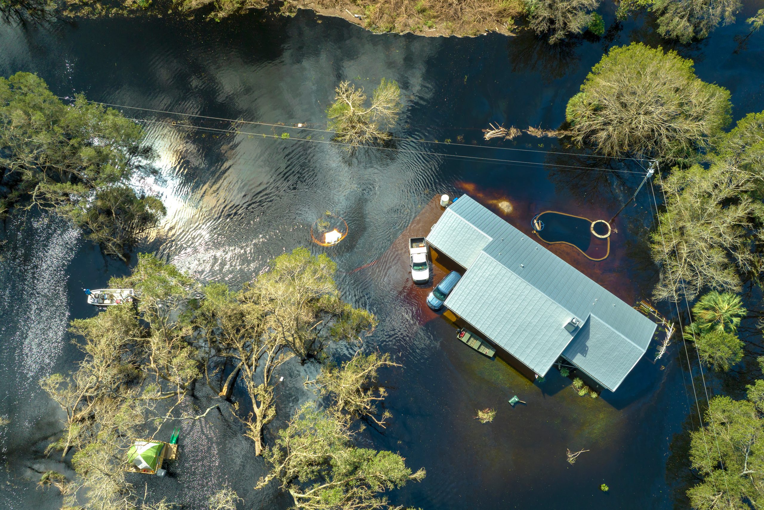
The project team led by Olabarrieta predicts the impacts from flooding, coastal erosion, infrastructure damage and breaching. Breaching occurs when a barrier island that has low and narrow dunes is eroded by waves and coastal currents, creating a new opening through which water rushes in and potentially damages infrastructure, habitats and threatens the safety of people living in the area. The ability to predict breaches is thus critical to protecting communities and ecosystems.
“This year, we have seen extreme sea surface temperature fields and that is very dangerous because it increases the probability of rapid intensification of hurricanes,” said Olabarrieta. “What we have seen in the last year is our hurricanes are bigger and they are stronger, and they have a lot of rain as well. The hazards associated with tropical cyclones are increasing and we need to have better tools to predict what is going to be the impact on our infrastructure.”
Much of the uncertainty in predicting hurricane impacts comes from uncertainty in atmospheric predictions (such as hurricane track, intensity, and size), but factors such as vegetation coverage and effects of the built environment are also important. This large-scale, collaborative research effort seeks to reduce these uncertainties by comparing atmospheric and ocean forecasts made before a hurricane hits to measurements taken during and after a storm. Researchers can then identify how well the models perform and how they can be improved.
Olabarrieta’s team focuses specifically on forecasting the waves, surge, sediment transport and damage to structures from the hurricane. Her team includes Assistant Professor Arthriya Subgranon, Ph.D., from the Department of Civil and Coastal Engineering, and Ph.D. student Steven Klepac, who are using artificial intelligence to determine the impact of storms on residential communities and buildings. Other collaborators on Olabarrieta’s team include scientists from the United States Geological Survey (USGS), Louisiana State University (LSU) and Fathom Science.
Olabarrieta’s team aims to provide a daily forecast of hurricane-related coastal impacts beginning five days before a hurricane makes landfall and to do so for three hurricanes each season, from 2022 to 2024. Their forecasting system integrates multiple models to be able to provide more efficient and accurate warning systems.
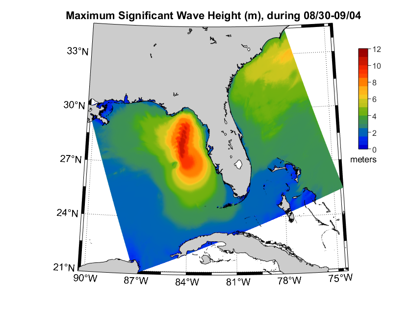
Buoys are thrown out of an aircraft to gather data on waves, sea level pressure and storm tide during the hurricane. The data is incorporated into hurricane forecasting models to predict impacts on coastal areas. These efforts are led by Luca Centurioni, Ph.D., director of the Lagrangian Drifter Laboratory, Jim Thomson, Ph.D., principal oceanographer at the University of Washington’s Applied Physics Laboratory and USGS Research Oceanographer Jenna Brown, members of a large team of researchers working in tandem to improve the predictive capability of hurricane models.
The growing intensity and frequency of weather events points to an urgent need for being able to quantify the uncertainties associated with predictions for extreme weather events, allowing modelers to make more accurate forecasts and improve emergency response in affected areas. Uncertainties can include slight variations in the predicted track of the hurricane, for example. These slight variations have significant impacts on the time frame window for the team’s work, from deploying sensors in the ocean before the hurricane arrives to the level of resolution they can generate for forecasting.
“I think that we need to communicate to communities in Florida that there is this uncertainty associated with our predictions and that if we have a better understanding of this uncertainty, we will be able to respond to those hurricanes in a more efficient way,” said Olabarrieta. “So far, we have been pretty successful in getting the data, making the predictions and making the comparisons between our predictions and what happened to better understand and predict hurricane impacts.”
The public-private teams are led by experts from the U.S. Naval Research Laboratory (NRL), United States Geological Survey (USGS), NOAA, the University of Miami: Rosenstiel School of Marine and Atmospheric Science, Scripps Institution of Oceanography’s Lagrangian Drifter Laboratory, University of Washington’s Applied Physics Laboratory, UNC Chapel Hill, Deltares and the University of Florida.
Industry collaborators also include Capella Space, Seahorse Coastal Consulting, Fathom Science, Sofar, The Water Institute and Airbus Defense and Space. Government partners include the National Weather Service, National Centers for Environmental Protection and the National Geospatial Intelligence Agency. Team members from academia include Renci, Woods Hole Oceanographic Institution, Louisiana State University (LSU), IHE Delft, North Carolina State University, University of Georgia, University of Massachusetts Amherst, Center for Southeastern Tropical Advanced Remote Sensing, University of Rhode Island’s Graduate School of Oceanography and Oregon State University.